France: total motorcycle touring trips prepared for you
Tour 1: Brittany and Normandy

Total distance: 930 miles. Riding time: five days
Plenty of sightseeing opportunities on this pillion-friendly tour, from the D-Day beaches to the U-boat pens in St Nazaire to the Bayeux Tapestry. This is a relaxed route with low average daily mileages (the first is especially short to allow a visit to Mont St-Michel).
DAY ONE: Caen to Dinan (150 miles)
Route map, Download the GPX
DAY TWO: Dinan to Quimper (185 miles)
Route map, Download the GPX
DAY THREE: Quimper to St Nazaire (185 miles)
Route map, Download the GPX
DAY FOUR: St Nazaire to Alençon (190 miles)
Route map, Download the GPX
DAY FIVE: Alençon to Caen (220 miles)
Route map, Download the GPX
Tour 2: The Vosges and Doubs
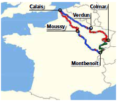
Total distance: 1225 miles Riding time: Five days
It’s great roads and plenty to see all the way – from the memorials of the Somme to those of Verdun, through the mountains of the Haut-Doubs and the Vosges. The first day requires a morning crossing to Calais, while the final day uses a little motorway to get home fast.
DAY ONE: Calais to Moussy (230 miles)
Route map, Download the GPX
DAY TWO: Moussy to Montbenoït (245 miles)
Route map, Download the GPX
DAY THREE: Montbenoït to Colmar (250 miles)
Morning route map, Afternoon route map Download the GPX
DAY FOUR: Colmar to Verdun (255 miles)
Route map, Download the GPX
DAY FIVE: Verdun to Calais (245 miles)
Route map, Download the GPX
Tour 3: Ardennes, Morvan and Jura

Total distance: 1145 miles. Riding time: Five days
This is a real 'rider’s' tour, with the emphasis on flowing and twisty roads through unspoilt countryside, rather than on stopping to see the sights. The first day needs a late-morning crossing to Calais.
DAY ONE: Calais to Monthermé (195 miles)
Route map, Download the GPX
DAY TWO: Monthermé to Avallon (250 miles)
Route map, Download the GPX
DAY THREE: Avallon to Arbois (265 miles)
Route map, Download the GPX
DAY FOUR: Arbois to Nanteuil-sur-Marne (245 miles)
Route map Download the GPX
DAY FIVE: Nanteuilsur-Marne to Calais (190 miles)
Route map, Download the GPX
Tour 4: The Loire and Limousin

Total distance: 970 miles. Riding time: five days
Based around the overnight ferry services to and from Caen, this relaxed tour offers plenty of chances to stop and explore the sights – including one or two of the châteaux of the Loire valley – but still has plenty of rewarding roads to ride.
DAY ONE: Caen to Amboise (200 miles)
Route map, Download the GPX
DAY TWO: Amboise to Mansle (195 miles)
Route map, Download the GPX
DAY THREE: Mansle to St Etienne-de-Fursac (185 miles)
Route map, Download the GPX
DAY FOUR: St Etienne -de-Fursac to Sandillon (175 miles)
Route map, Download the GPX
DAY FIVE: Sandillon to Caen (215 miles)
Route map, Download the GPX
Tour 5: The Alps (high-mileage)

Total distance: 1785 miles. Riding time: Seven days
All the great passes plus the Gorges du Verdon are on this intense week-long trip, with full days suitable for solo riders. Easily extended with extra days to ride loops around Bourg-St-Maurice, Barcelonette or Castellane, or you could plan a rest day or two into the trip.
DAY ONE: Calais to Chatillon-sur-Seine (285 miles)
Route map, Download the GPX
DAY TWO: Chatillon-sur-Seine to Bourg-St-Maurice (265 miles)
Route map, Download the GPX
DAY THREE: Bourg-St-Maurice to Barcelonette (195 miles)
Route map, Download the GPX
DAY FOUR: Barcelonette to Castellane (250 miles)
Route map, Download the GPX
DAY FIVE: Castellane to Tence (260 miles)
Route map, Download the GPX
DAY SIX: Tence to Mesnil-St-Pierre (265 miles)
Route map, Download the GPX
DAY SEVEN: Mesnil-St-Pierre to Calais (265 miles)
Route map, Download the GPX
Tour 6: The Alps (relaxed)

Total distance: 2050 miles. Riding time: Nine days
Epic riding through the Morvan, Auvergene, Tarn gorges, Cévennes, Provençe, Jura and Vosges as well as the Alps. Higher-mile days use motorway to keep time in the saddle down to pillion-friendly levels.
DAY ONE: Calais to Vouziers (190 miles)
Route map, Download the GPX
DAY TWO: Vouziers to Luzy (250 miles)
Route map, Download the GPX
DAY THREE: Luzy to Mende (250 miles)
Route map, Download the GPX
DAY FOUR: Mende to Bollène (210 miles)
Route map, Download the GPX
DAY FIVE: Bollène to Valberg (210 miles)
Route map, Download the GPX
DAY SIX: Valberg to Grenoble (225 miles)
Route map, Download the GPX
DAY SEVEN: Grenoble to St-Hippolyte (225 miles)
Route map, Download the GPX
DAY EIGHT: St-Hippolyte to Châlons-en-Champagne (280 miles)
Route map, Download the GPX
DAY NINE: Châlons-en-Champagne to Calais (210 miles)
Route map, Download the GPX
Tour 7: The Pyrenees (high-mileage)
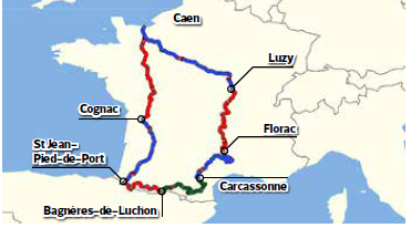
Total distance: 1895. Riding time: seven days
Using overnight crossings to and from Caen, this tour takes in all our favourite roads in the French Pyrenees – plus the Cévennes and Auvergne on the way back. Longer days in the saddle may be better suited to solo riders than pillion couples.
DAY ONE: Caen to Cognac (320 miles)
Route map, Download the GPX
DAY TWO: Cognac to St Jean-Pied-de-Port (240 miles)
Route map, Download the GPX
DAY THREE: St Jean-Pied-de-Port to Bagnères-de-Luchon (210 miles)
Route map, Download the GPX
DAY FOUR: Bagnères-de-Luchon to Carcassonne (250 miles)
Route map , Download the GPX
DAY FIVE: Carcassonne to Florac (240 miles)
Route map, Download the GPX
DAY SIX: Florac to Luzy (285 miles)
F=Route map, Download the GPX
DAY SEVEN: Luzy to Caen (350 miles)
Route map, Download the GPX
Tour 8: The Pyrenees (relaxed)
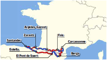
Total distance: 1390 miles. Riding time: Eight days
This pillion-friendly tour of both sides of the Pyrenees ties into the Santander ferry crossings. There’s lots to see, as the route takes in many of the Cathar castles on the French side of the mountains.
DAY ONE: Santander to Zarautz (150 miles)
Route map, Download the GPX
DAY TWO: Zarautz to Argèles-Gazost (185 miles)
Route map, Download the GPX
DAY THREE: Argèles-Gazost to Foix (170 miles)
Route map, Download the GPX
DAY FOUR: Foix to Carcassonne (180 miles)
Route map, Download the GPX
DAY FIVE: Carcassonne to Berga (175 miles)
Route map, Download the GPX
DAY SIX: Berga to El Pont de Suert (180 miles)
Route map, Download the GPX
DAY SEVEN: El Pont de Suert to Estella (205 miles)
Route map, Download the GPX
DAY EIGHT: Estella to Santander (145 miles)
Route map, Download the GPX
Tour 9: The Bikeshuttle tour

Total distance: 1645 miles. Riding time: Eight days
Don’t want to ride across Northern France? You don’t have to: this trip starts in the Jura and heads through the Alps, Auvergne and Vosges. It ties in with the Bikeshuttle service that ships your bike to France (see www.bikeshuttle.co.uk). If you want to cut it short, you could take the Bikeshuttle on the way out and then ride straight home from Chaumont after five memorable days.
DAY ONE: St Genis-Pouilly to Gresse-en-Vercors (155 miles)
Route map, Download the GPX
DAY TWO: Gresse-en-Vercors to Vallon-Pont-d’Arc (220 miles)
Route map, Download the GPX
DAY THREE: Vallon-Pont-d’Arc to Aurillac (235 miles)
Route map, Download the GPX
DAY FOUR: Aurillac to Thiers (205 miles)
Route map, Download the GPX
DAY FIVE: Thiers to Chaumont (230 miles)
Route map, Download the GPX
DAY SIX: Chaumont to Wasselonne (230 miles)
Route map, Download the GPX
DAY SEVEN: Wasselonne to Besançon (230 miles)
Route map, Download the GPX
DAY EIGHT: Besançon to St Genis-Pouilly (140 miles)
Route map, Download the GPX
Tour 10: Millau tour

Total distance: 1740 miles. Riding time: Eight days
The trip that has everything – mountains, gorges, castles, cathedrals and one enormous bridge. With moderate mileages and lots to see along the way, this is a good trip for pillion couples or first-time solo European tourists wanting a longer tour.
DAY ONE: Calais to Moussy (215 miles)
Route map, Download the GPX
DAY TWO: Moussy to Arbois (230 miles)
Route map, Download the GPX
DAY THREE: Arbois to Grenoble (190 miles)
Route map, Download the GPX
DAY FOUR: Grenoble to Pertuis (215 miles)
Route map, Download the GPX
DAY FIVE: Pertuis to Millau (205 miles)
Route map , Download the GPX
DAY SIX: Millau to Treignac (235 miles)
Route map, Download the GPX
DAY SEVEN: Treignac to Chartres (250 miles)
Route map, Download the GPX
DAY EIGHT: Chartres to Calais (200 miles)
Route map, Download the GPX
Tour 11: Limousin, Auverge, Cévennes

Total distance: 1885 miles. Riding time: Seven days
Like short, easy days on straight roads? Then this tour is NOT for you… It’s a high-mile blast on a seemingly-endless succession of sublime twisty roads. It doesn't have the tight hairpins and big drops of the high mountains, just a relentless stream of great bends. It ties into the overnight ferry service to and from Caen. Longer days and higher mileages mean this trip's ideal for sporty solo riders but not so suitable for pillion couples.
DAY ONE: Caen to Treignac (350 miles)
Route map, Download the GPX
DAY TWO: Treignac to Mende (265 miles)
Route map, Download the GPX
DAY THREE: Mende to Anduze (265 miles)
Route map, Download the GPX
DAY FOUR: Anduze to Vorey-sur-Arzon (265 miles)
Route map, Download the GPX
DAY FIVE: Vorey-sur-Arzon to Issoire (235 miles)
Route map, Download the GPX
DAY SIX: Issoire to La Châtre (245 miles)
Route map, Download the GPX
DAY SEVEN: La Châtre to Caen (260 miles)
Route map, Download the GPX
Tour 12: All France (high mileage)

Total distance: 3195 miles. Total times: 12 days
A highlight-packed high-mile tour for riders who want to fill every moment of each day with brilliant riding. Only the first and last days use motorways, so these are long days: it’s more suited to solo riders than pillion couples. We suggest taking a full two weeks for the tour and including a couple of rest days along the way.
DAY ONE: Calais to Verdun (245 miles)
Route map, Download the GPX
DAY TWO: Verdun to St-Hippolyte (280 miles)
Route map, Download the GPX
DAY THREE: St-Hippolyte to Bourg-St-Maurice (265 miles)
Route map, Download the GPX
DAY FOUR: Bourg-St-Maurice to Castellane (275 miles)
Route map, Download the GPX
DAY FIVE: Castellane to Anduze (280 miles)
Route map, Download the GPX
DAY SIX: Anduze to Carcassonne (250 miles)
Route map, Download the GPX
DAY SEVEN: Carcassonne to Bagnères-de-Luchon (255 miles)
Route map, Download the GPX
DAY EIGHT: Bagnères-de-Luchon to Villeneuve-sur-Lot (270 miles)
Route map, Download the GPX
DAY NINE: Villeneuve-sur-Lot to Issoire (290 miles)
Route map, Download the GPX
DAY TEN: Issoire to Richelieu (275 miles)
Route map, Download the GPX
DAY 11: Richelieu to Bayeux (280 miles)
Route map, Download the GPX
DAY 12: Bayeux to Calais (230 miles)
Route map, Download the GPX
Tour 13: All France (relaxed)
Total distance: 3075 miles. Riding time: 15 days

Got two weeks off? A new set of tyres? Take our relaxed, pillion-friendly lap of France, taking in the best sights and finest roads. It’s all flowing, open riding – only the final day uses any significant stretch of motorway, just to get you back to Calais quickly.
DAY ONE: Calais to Beauvais (185 miles)
Route map, Download the GPX
DAY TWO: Beauvais to Bayeux (205 miles)
Route map, Download the GPX
DAY THREE: Bayeux to Châteaubriant (210 miles)
Route map, Download the GPX
DAY FOUR: Châteaubriant to St Etienne-de-Fursac (230 miles)
Route map, Download the GPX
DAY FIVE: St Etienne-de-Fursac to Villeneuve-sur-Lot (220 miles)
Route map, Download the GPX
DAY SIX: Villeneuve-sur-Lot to Argèles-Gazost (215 miles)
Route map, Download the GPX
DAY SEVEN: Argèles-Gazost to Foix (170 miles)
Route map, Download the GPX
DAY EIGHT: Foix to Millau (210 miles)
Route map, Download the GPX
DAY NINE: Millau to Orange (190 miles)
Route map, Download the GPX
DAY TEN: Orange to Castellane (185 miles)
Route map, Download the GPX
DAY 11: Castellane to Lanslebourg-Mont-Cenis (195 miles)
Route map, Download the GPX
DAY 12: Lanslebourg-Mont-Cenis to St Claude (175 miles)
Route map, Download the GPX
DAY 13: St Claude to Thann (200 miles)
Route map, Download the GPX
DAY 14: Thann to Pont-à-Mousson (200 miles)
Route map, Download the GPX
DAY 15: Pont-à-Mousson to Calais (285 miles)
Route map, Download the GPX
Please note: This page contains the motorcycle touring routes for The RiDE Guide To France which came free with RiDE magazine in July 2017. These website pages are not regularly updated, so please check all critical information before you travel. All route files are in .gpx format. Garmin and BMW users can download the main file, which contains all the routes. TomTom users can either download the individual routes or use the MyRouteApp (depending on the age of your device). For many routes we also have Google Map links. However, as Google Maps will not plot routes over seasonally closed roads, such as high Alpine passes when they’re shut, so these may not work for every route all year round.