A ride around Cosenza, Calabria
Route 23: A ride around Cosenza, Calabria
With brilliant roads all around it, Cosenza should be a destination, not a stop-over

Miles of empty roads baked by the fierce sun of Calabria
Most people heading to Sicily just sit on the motorway from Rome all the way to the ferry from Reggio to Messina. Depending on timing, they might stop off in Cosenza as they cross Calabria, the toe of Italy. But that’s it: a bed for the night, then back on the motorway. If riding past Potenza is a mistake, then blasting by Cosenza on a motorcycle tour in Italy is an utter disaster. The hills around this compact city are crammed with some of the most relentlessly twisty roads - not just in Calabria nor even in Italy, but in all of Europe. Better still, they’re usually silent, but for the whisper of the wind and the occasional warble of birdsong.
We have three great routes here guaranteed to make your head spin, not with dizziness but with the sheer pleasure of getting to grips with these roads. Unlike the motorway drivers blasting south, we know how to enjoy ourselves - and that’s by riding these roads.
MAPS AND DOWNLOADS FOR A RIDE AROUND COSENZA, CALABRIA
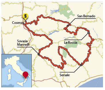

Route 1 (our route): start/finish: Cosenza. Distance: 210 miles. Riding time: 6.5 hours. Suggested stops: AM coffee: San Bernado, lunch: Sersale, PM coffee: Soveria Mannelli
Route one map, Route one GPX file
Route 2: Distance: 205 miles. Riding time: 7 hours. Extra-twisty roads down to the southern coast
Route two map, Route two GPX file
Route 3: Distance: 200 miles. Riding time: 7 hours. Adventure bike route on twisty roads to the east coast
Route three map, Route three GPX file
Please note: This page contains the route files for The RiDE Guide To Italy which came free with RiDE magazine in July 2015. These website page are not regularly updated, so please check all critical information before you travel. All route files are in .gpx format. Garmin and BMW users can download the main file, which contains all the routes and our recommended hotels as separate waypoints. TomTom users can download the individual routes and use the Tyre software to convert them. For many routes we also have Google Map links. However, as Google Maps will not plot routes over seasonally closed high Alpine passes (such as Stelvio) when they’re shut, these may not work for every route all year round.