A ride around Chieti, Abruzzo
Route 18: A ride around Chieti, Abruzzo
Don’t follow the herd for high-altitude thrills: head south to find the wilder, quieter mountains for a wonderful motorcycle tour in Abruzzo.

From quiet towns to deserted mountains and placid valleys
The central Apennines drop to the east coast of Italy like a hawk stooping on a rabbit. There’s only one reaction: like a fleeing rabbit, jink left and right crazily, adrenaline-sharpening reactions… not because a giant killer bird is coming at you, but because the road is going headlong down the mountainside in a cascade of corners and hairpins that would set anyone’s heart pumping.
You might have thought that getting as far south as Rome meant the mountains were behind you, but not at all. It’s so high there’s skiing in winter and the views down ice-carved valleys and across limpid lakes wold be right at home in any corner of the Alps. The thing is, not so many people know that, so the Majella Massif is surprisingly quiet - unlike the Alps, it doesn’t draw hordes of pass-bagging riders, even though it’s home to some of the highest peaks in the Apennines.
Our routes radiate from the town of Chieti - just outside the bustling port city of Pescara. The road quality is perhaps more variable this far south but you don’t need an adventure bike to enjoy these roads - especially not the well-surfaced sweepers carving along the valley floors and the runs of broad hairpins climbing the slopes. Particularly as you’ll very likely have them to yourself: after all, who’d think you would find brilliant mountain motorcycle riding so far south of the Alps? It’s here… but the crowds of German-plated GSs aren’t.
MAPS AND DOWNLOADS FOR A RIDE AROUND CHIETI, ABRUZZO
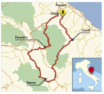

Route 1 (our route): start/finish: Chieti. Distance: 155 miles. Riding time: 4.5 hours. Suggested stops: AM coffee: Casoli, lunch: Barrea, PM coffee: Pacentro
Route one map, Route one GPX file
Route 2: Distance: 235 miles. Riding time: 7 hours. An extended loop through the Majella and Monte Genzana areas
Route two map, Route two GPX file
Route 3: Distance: 180 miles. Riding time: 5.5 hours. Flowing roads climbing into the Gran Sasso
Route three map, Route three GPX file
Please note: This page contains the route files for The RiDE Guide to motorcycle touring in Italy which came free with RiDE magazine in July 2015. These website page are not regularly updated, so please check all critical information before you travel. All route files are in .gpx format. Garmin and BMW users can download the main file, which contains all the routes and our recommended hotels as separate waypoints. TomTom users can download the individual routes and use the Tyre software to convert them. For many routes we also have Google Map links. However, as Google Maps will not plot routes over seasonally closed high Alpine passes (such as Stelvio) when they’re shut, these may not work for every route all year round.