Total Touring: Spain and Portugal
All of Spain and Portugal in ready-to-ride motorcycle tours


PICOS DE EUROPA TOUR
Total distance: 1005 miles Riding time: 6 days
OUT Plymouth/Santander (Sunday) BACK Santander/Portsmouth (Saturday evening)
We had a six-day Picos tour in the original Guide to Spain. This version has been updated, with feedback from those who did that first version (and some local tips). Day Four is short, to allow some sightseeing in Santiago de Compostela, but the final day is a full one, for the Saturday evening sailing.
Day One: Santiago to Panes, 100 miles/4 hours
Download GPX file
Day two: Panes to Luarca, 190 miles/6 hours Morning route Afternoon route
Download GPX file
Day three: Luarca to Santiago de Compostela, 210 miles/6 hours
Download GPX file
Day four: Santiago de Compostela to Ourense, 95 miles/3 hours
Download GPX file
Day five: Ourense to Leon, 210 miles/6 hours
Download GPX file
Day six: Leon to Santander, 200 miles/6 hours
Download GPX file
SPANISH PYRENEES TOUR

Total distance: 1305 miles Riding time: 6 days
OUT Plymouth/Santander (Sunday) BACK Santander/Portsmouth (Saturday, evening)
This corner-heavy tour focuses on the Spanish side of the mountains, with longer days in the saddle. The long final day ties into the Saturday evening sailing, but if you want to ride a couple of daytrips, use the shorter final day of the eight-day trip to catch the Monday afternoon sailing.
Day one: Santander to Pamplona, 175 miles/4.5 hours Download GPX file
Day two: Pamplona to Vielha, 245 miles/6.5 hours
Download GPX file
Day three: Vielha to Ripoll, 220 miles/6.5 hours
Download GPX file
Day four: Ripoll to Ainsa, 225 miles/6 hours
Download GPX file
Day five: Ainsa to Olaberria, 230 miles/6.5 hours
Download GPX file
Day six: Olaberria to Santander, 210 miles/7 hours
Download GPX file

SPANISH & FRENCH PYRENEES TOUR
Total distance: 1385 miles Riding time: 8 days
OUT Plymouth/Santander (Sunday) BACK Santander/Portsmouth (Monday)
This is the latest, gently updated version of our popular, pillion-friendly eight-day trip. The emphasis is on big views, rather than big miles, though each day is still a solid ride. It takes in the French Pyrenees as well as the Spanish – after all, if you’re there, why not see both sides of the mountains?
Day one: Santander to Zarautz, 150 miles/4.5 hours
Download GPX file
Day two: Zarautz to Argeles-Gazost, 185 miles/5.5 hours
Download GPX file
Day three: Argeles-Gazost to Foix, 170 miles/5 hours
Download GPX file
Day four: Foix to Carcassonne, 180 miles/5 hours
Download GPX file
Day five: Carcassonne to La Seu d’Urgell, 180 miles, 5.5 hours
Download GPX file
Day six: La Seu d’Urgell to Jaca, 205 miles, 5.5 hours
Download GPX file
Day seven: Jaca to Olaberria, 180 miles/5 hours
Download GPX file
Day eight: Olaberria to Santander, 135 miles/4 hours
Download GPX file
PYRENEES & PICOS HIGH-MILE TOUR

Total distance: 1680 miles Riding time: 8 days
OUT Plymouth/Santander (Sunday) BACK Santander/Portsmouth (Monday)
This really is the best of both worlds: eight days, two mountain ranges, one mindblowing tour. A real mountain-lovers’ trip, mileages are high – late starts and long lunches are not recommended. This tour uses several Brittany Ferries partner hotels, but adapt the stops if they don’t suit.
Day one: Santander to Olite, 170 miles, 4.5 hours
Download GPX file
Day two: Olite to Cellers, 245 mile, 6 hours
Download GPX file
Day three: Cellers to Vielha, 250 miles, 7 hours
Download GPX file
Day four: Vielha to Pamplona, 230 miles, 6.5 hours
Download GPX file
Day five: Pamplona to Potes, 240 miles, 7 hours
Download GPX file
Day six: Potes to Cangas de Narcea, 210 miles, 6.5 hours
Download GPX file
Day seven: Cangas de Narcea to Ribadasella, 215 miles, 7 hours
Download GPX file
Day eight: Ribadasella to Santander, 120 miles, 3.5 hours
Download GPX file
PICOS AND NORTHERN PORTUGAL RELAXED TOUR

Total distance: 1355 miles. Riding time: 8 days
OUT Plymouth/Santander (Sunday) BACK Santander/Portsmouth (Monday)
Desperate to see the Douro Valley and the Serra da Estrela, but don’t want to miss out on the best bits of the Picos? Then this is for you: all the best bits of Spain’s northcoast mountains plus the highlights of the riding in Northern Portugal – all packaged up in pillion-friendly days.
Day one: Santander to Cangas de Onis, 105 miles, 3 hours
Download GPX file
Day two: Cangas de Onis to Cangas de Narcea, 165 miles, 5.5 hours
Download GPX file
Day three: Cangas de Narcea to Chaves, 205 miles, 6 hours
Download GPX file
Day 4: Chaves to Covilha, 190 miles, 6 hours
Download GPX file
Day 5: Covilha to Vila Real, 175 miles, 6 hours
Download GPX file
Day 6: Vila Real to Puebla de Sanabria, 190 miles, 6 hours
Download GPX file
Day 7: Puebla de Sanabria to Potes, 190 miles, 6 hours
Download GPX file
Day 8: Potes to Santander, 135 miles, 4 hours
Download GPX file
CENTRAL SPAIN AND PORTUGAL TOUR

Total distance: 1485 miles. riding time: 8 days
OUT Plymouth/Santander (Sunday) BACK Santander/Portsmouth (Monday)
This action-packed trip includes Portugal’s Serra da Estrela mountains and Douro Valley, plus plenty of passes in the Picos de Europa and throws in a hearty dose of historic central Spain as well, with stops in Burgos, Segovia and Ciudad Rodrigo. Eight great days in a series of lovely landscapes.
Day one: Santander to Burgos, 120 miles, 3.5 hours
Download GPX file
Day two: Burgos to Segovia, 215 miles, 5.5 hours
Download GPX file
Day three: Segovia to Guadalupe, 215 miles, 5.5 hours
Download GPX file
Day four: Guadalupe to Castelo Branco, 210 miles, 6 hours
Download GPX file
Day five: Castelo Branco to Cuidad Rodrigo, 205 miles, 6 hours
Download GPX file
Day six: Cuidad Rodrigo to Bragança, 190 miles, 6 hours
Download GPX file
Day seven: Bragança to Potes, 210 miles, 6 hours
Download GPX file
Day eight: Potes to Santander, 120 miles, 4 hours
Download GPX file
PORTUGAL HIGH-MILE TOUR 1

Total distance: 1990miles Riding time: 10 days
OUT Plymouth/Santander (Sunday) BACK Santander/Plymouth (Wednesday)
A fantastic, extended, corner-heavy tour through Portugal – with a rest day included. First printed in our Tour 2016 supplement, it’s become one of the most popular routes we’ve ever published. From the verdant mountains of the Picos to the terraced slopes of the Douro Valley, the surf-kissed beaches of the Algarve and the summit of Torre in the Serra da Estrela, it’s mile after mile of rewarding riding... a lot of riding, hence the rest day.
Day one: Santander to Sahagun, 140 miles, 3.5 hours
Download GPX file
Day two: Sahagun to Vila Real, 245 miles, 6.5 hours
Download GPX file
Day three: Vila Real to Serta, 205 miles, 6 hours
Download GPX file
Day four: Serta to Luz, 265 miles, 7 hours
Download GPX file
Day five: Luz to Elvas, 245 miles, 7 hours
Download GPX file
Day six: Elvas to Covilha, 230 miles, 6.5 hours
Download GPX file
Day seven: Covilha to Chaves, 210 miles, 6.5 hours
Download GPX file
Day eight: Chaves to Astorga, 225 miles, 6.5 hours
Download GPX file
Day nine: Astorga to Santander, 230 miles, 6.5 hours
Download GPX file
HISTORIC CITIES TOUR

Total distance: 1280 miles Riding time: 8 days
OUT Plymouth/Santander (Sunday) BACK Santander/Portsmouth (Monday)
Ideal for pillion couples, this laid-back tour of historic cities allows time to explore each overnight destination – and features a short third day to allow extra time in Segovia, Coca Castle and Ávila. The riding is still the star attraction though, with stunning views and brilliant bends packed into very easily managed days.
Day One Santander to Burgos, 120 miles, 3.5 hours
Download GPX file
Day Two Burgos to Segovia, 190 miles, 4.5 hours
Download GPX file
Day Three Segovia to Avila, 85 miles, 2.5 hours NB: short day for sightseeing
Download GPX file
Day Four Avila to Toledo, 145 miles, 4.5 hours
Download GPX file
Day 5 Toledo to Cuenca, 195 miles, 5 hours
Download GPX file
Day 6 Cuenca to Morella, 185 miles, 5 hours
Download GPX file
Day 7 Morella to Estella, 215 miles, 5 hours
Download GPX file
Day 8 Estella to Santander, 145 miles, 4 hours
SPANISH FOREST RELAXED 6-DAY TOUR

Total distance: 1150miles Riding time: 6 days
OUT Plymouth/Santander (Sunday) BACK Santander/Portsmouth (Saturday, evening)
This tour – first featured in the Tour 2018 supplement – is built around visiting the historic gem of Segovia, with two day-trip loops radiating from the city. One is all about the riding, heading out through beautiful forests; the other heads out to other sightseeing locations – but can easily be dropped for a day off the bike, exploring Segovia itself. The long final day is for an evening ferry, but is easily shortened if necessary to meet an alternative crossing.
Day one: Santander to Logroño 150 miles Riding time: 3.5 hours
Download GPX file
Day two: Logroño to Segovia 200 miles Riding time: 4.5 hours
Download GPX file
Day three: Segovia forest daytrip 175 miles Riding time: 6 hours
Download GPX file
Day four: Segovia optional daytrip 175 miles Riding time: 5 hours
Download GPX file
Day five: Segovia to Potes 220 miles Riding time: 5 hours
Download GPX file
Day six: Potes to Santander 230 miles Riding time: 7 hours NB: Full-day’s route for evening sailing
Download GPX file
EASTERN SPAIN AND PYRENEES 8-DAY HIGH-MILE TOUR

Total distance: 1840 miles Riding time: 8 days
OUT Plymouth/Santander (Sunday) BACK Santander/Portsmouth (Monday)
A real ‘rider’s trip’ this one – plenty of miles each day on a succession of astonishing roads. Sweeping through the sierras of central Spain and across the plains, before heading back to Santander through the fabulous Pyrenees, there’s every kind of landscape — and corner — imaginable. It’s not a trip for the first-time tourist or pillion couples, but it’s ideal for solo riders who want the emphasis firmly on the riding.
Day one: Santander to Logroño, 150 miles, 4.5 hours
Download GPX file
Day two: Logroño to Albarracin, 270 miles, 7 hours
Download GPX file
Day three: Albarracin to Riopar, 270 miles, 7 hours
Download GPX file
Day four: Riopar to Requena, 230 miles, 6.5 hours
Download GPX file
Day five: Requena to Reus, 270 miles, 7 hours
Download GPX file
Day six: Reus to Sort, 230 miles, 7 hours
Download GPX file
Day seven: Sort to Estella, 270 miles, 7 hours
Download GPX file
Day eight: Estella to Santander, 150 miles, 4 hours
Download GPX file
EAST SPAIN EIGHT-DAY TOUR

Total distance: 1615 miles Riding time: 8 days
OUT Plymouth/Santander (Sunday) BACK Santander/Portsmouth (Monday)
From the green slopes of the Picos de Europa to ancient Cartagena on the Mediterranean coast – by way of historic walled towns, empty sierras, dramatic gorges, rolling sun-baked plains and mile after mile of brilliant roads. This is a tour that puts the emphasis on riding satisfaction, getting off the beaten track to explore unspoiled, untouristy parts of Spain. Each day delivers a lot of spectacular riding on twisty Tarmac but with flowing roads and sensible distances it’s a tour that will work for confident pillions or bigger groups as well as solo riders and small groups.
Day one: Santander to Logrono, 150 miles, 4 hours Download GPX file
Day two: Logorono to Albarracin, 250 miles, 6 hours
Download GPX file
Day three: ALbarracin to Xativa, 190 miles, 5.5 hours
Download GPX file
Day four: Xativa to Cartagena, 200 miles, 6 hours Morning route Afternoon route
Download GPX file
Day five: Cartagena to Riopar, 205 miles, 6 hours
Download GPX file
Day six: Riopar to Guadalajara, 260 miles, 6 hours
Download GPX file
Day seven: Guadalajara to Burgos, 230 miles, 5.5 hours
Download GPX file
Day eight: Burgos to Santander, 130 miles, 3.5 hours
Download GPX file
ANDALUSIA SEVEN-DAY FLY-RIDE TOUR

Total distance: 1370 miles Riding time: 7 days
OUT Málaga (Saturday or early Sunday) FLIGHT BACK Málaga (Saturday night or Sunday)
You don’t have to ride to Andalusia: you could have your bike shipped out, or hire a bike when you get there, simply flying out and getting on your bike. This seven-day tour uses all our favourite Andalusian twists of Tarmac, from mountain passes to the Mediterranean shore, for an unforgettable trip to one of the world’s best riding regions. With short first and last days, it is possible to get an early flight out and a late flight back on those days… but we’d recommend flying the day before and after the trip, so there’s no rushing to get or return the bike.
Day one: Malaga to Ronda, 130 miles, 3.5 hours
Download GPX file
Day two: Ronda to Aracena, 240 miles, 7 hours
Download GPX file
Day three: Aracena to Antequerra, 235 miles, 7 hours
Download GPX file
Day four: Antequerra to Granada, 225 miles, 7 hours
Download GPX file
Day five Granada to Carboneras, 225 miles, 7 hours
Download GPX file
Day six: Carboneras to Salobreña, 220 miles, 6.5 hours
Download GPX file
Day seven: Salobreña to Malaga, 95 miles, 3.5 hours
Download GPX file
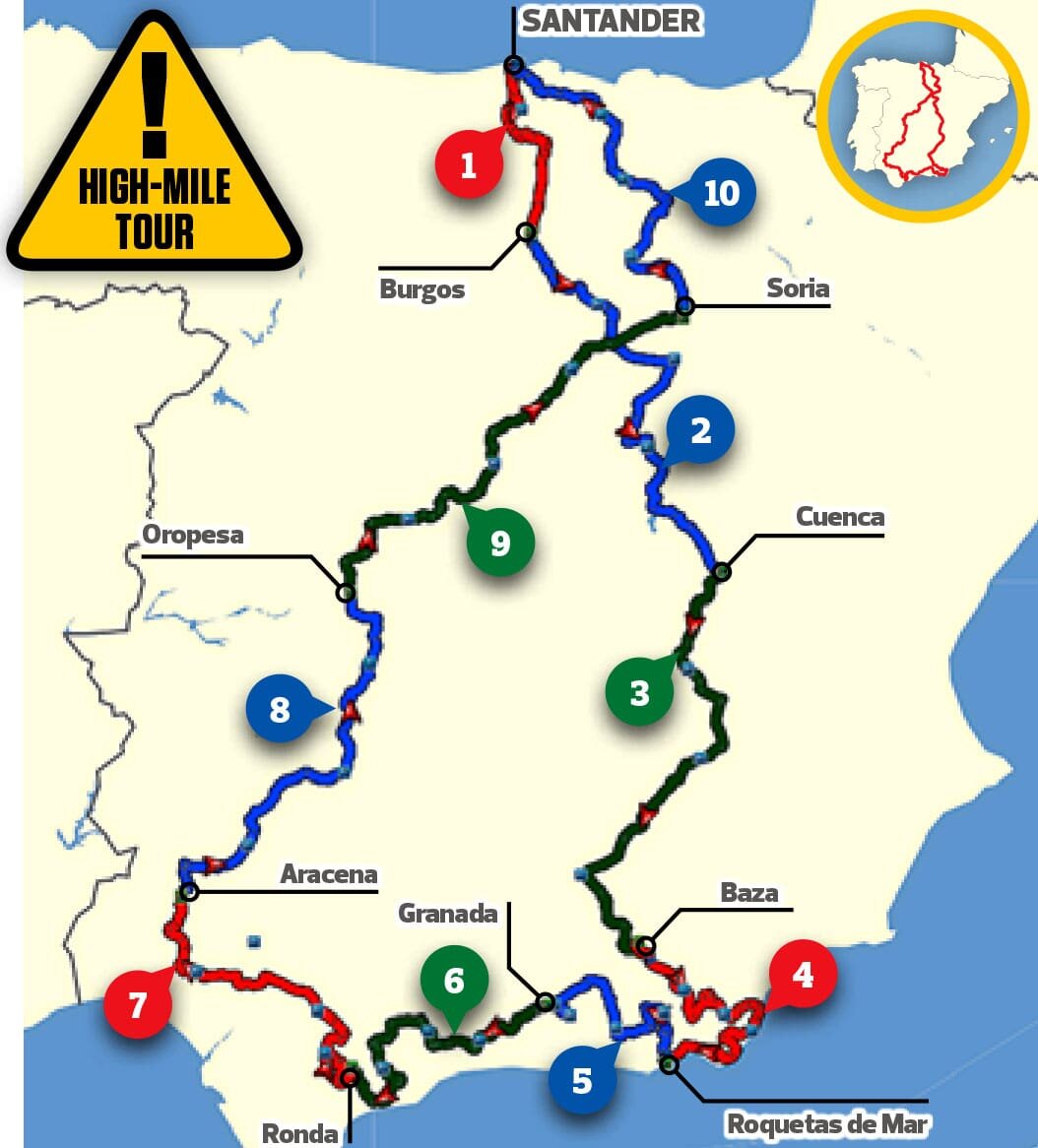
ANDALUSIA HIGH-MILE TOUR

Total distance: 2325 miles Riding time: 10 days
OUT Plymouth-Santander (Sunday) BACK Santander-Plymouth (Wednesday)
Andalusia may be a long way from Santander but when the ride there is this good, you know it makes sense. Especially as the riding when you get there is even better… From Alto de Velefique and the Sierra Nevada to the red waters of the Rio Tinto – not to mention all our favourite roads in between – this is a tour that literally drips with wow-factor. It’s a long trip and daily mileages are on the high side, making it more suitable for experienced tourists rather than first timers or pillion pairs. Easily extended if you have a full two weeks – just be aware that the final day’s route is a long one to meet the Wednesday evening departure: spread it over two days if staying on for a Sunday sailing.
Day one: Santander to Burgos, 120 miles, 3.5 hours
Download GPX file
Day two: Burgos to Cuenca, 270 miles, 6.5 hours
Download GPX file
Day three: Cuenca to Baza, 280 miles, 6.5 hours
Download GPX file
Day four: Baza to Roquetas de Mar, 230 miles, 6.5 hours
Download GPX file
Day five: Roquetas de Mar to Granada, 215 miles, 6.5 hours
Download GPX file
Day six: Granda to Ronda, 225 miles, 6.5 hours
Download GPX file
Day seven: Ronda to Aracena, 230 miles, 6.5 hours
Download GPX file
Day eight: Aracena to Oropesa, 250 miles, 6.5 hours
Download GPX file
Day nine: Oopesa to Soria, 270 miles, 6.5 hours
Download GPX file
Day ten: Soria to Santander (evening sailing), 235 miles, 7 hours
Download GPX file
NB: full day’s ride to meet Wednesday evening sailing
The Grand Tour of Spain and Portugal
Total distance: 4130miles Riding time: 19 days
OUT Plymouth-Santander (Sunday) BACK Santander-Portsmouth (Monday)
Want to see all the great riding Spain and Portugal have to offer – on one gigantic tour? This one’s for you. Booking ferries not one but three weeks apart gives a colossal 19 days in which to explore – starting with the Pyrenees and Catalonia, heading inland to historic Cuenca on the way south. All the must-ride roads in Andalusia are here – from Alto de Velefique and the Sierra Nevada to the famous ‘Ronda road’ and the Rio Tinto – before heading to Portugal to take in the fortifications at Elvas, the Serra da Estrela mountains and the Douro Valley. Finally, the tour returns to Santander through the spectacular Picos de Europa mountains – after almost 4000 sublime miles. It’s a lot of riding so even though it’s spread over three weeks the schedule still allows for three rest days to be spaced out through the trip.
Day one: Santander to Pamplona, 175 miles, 4.5 hours Download GPX file
Day two: Pamplona to Vielha, 240 miles, 6.5 hours Download GPX file
Day three: Vielha to Igualada, 210 miles, 6 hours Download GPX file
Day four: Igualada to Morella, 220 miles, 6.5 hours
Download GPX file
Day five: Morella to Cuenca, 235 miles, 6.5 hours
Download GPX file
Day six: Cuenca to Xativa, 210 miles, 6 hours
Download GPX file
Day seven: Xativa to Riopar, 230 miles, 6.5 hours Morning route Afternoon route
Download GPX file
Day eight: Riopar to Carboneras, 225 miles, 6.5 hours
Download GPX file
Day nine: Carboneras to Granada, 225 miles, 6 hours
Download GPX file
Day 10: Granadato Ronda, 200 miles, 6.5 hours
Download GPX file
Day 11: Ronda to Mertola, 245 miles, 6.5 hours
Download GPX file
Day 12: Mertola to Elvas, 225 miles, 6 hours
Download GPX file
Day 13: Elvas to Covilha, 225 miles, 6.5 hours
Download GPX file
Day 14: Covilha to Guadalupe, 240 miles, 6.5 hours
Download GPX file
Day 15 Guadalupe to Cuidad Rodrigo. 235 miles, 6.5 hours
Download GPX file
Day 16 Cuidad Rodrigo to Chaves, 225 miles, 6.5 hours
Download GPX file
Day 17: Chaves to Ponferrada, 200 miles, 5.5 hours
Download GPX file
Day 18: Ponferrada to Potes, 240 miles, 6.5 hours
Download GPX file
Day 19: Potes to Santander, 125 miless, 4 hours
Download GPX file
Please note: This page contains the route files for The RiDE Guide to motorcycle touring in Spain and Portugal which came free with RiDE magazine in July 2018. These website page are not regularly updated, so please check all critical information before you travel. All route files are in .gpx format. Garmin and BMW users can download the main file, which contains all the routes and our recommended hotels as separate waypoints. TomTom users can download the individual routes and use the Tyre software to convert them. For many routes we also have Google Map links. However, as Google Maps will not plot routes over seasonally closed high Alpine passes (such as those in the Pyrenees) when they’re shut, these may not work for every route all year round.